
Article by Sam Winebaum
Suunto Vertical Titanium Solar Canyon ($839)
- Superb GPS accuracy
- Long battery life in test- 50 plus hours all satellite networks dual frequency Best Mode, 11 days with 105 min GPS activity/day
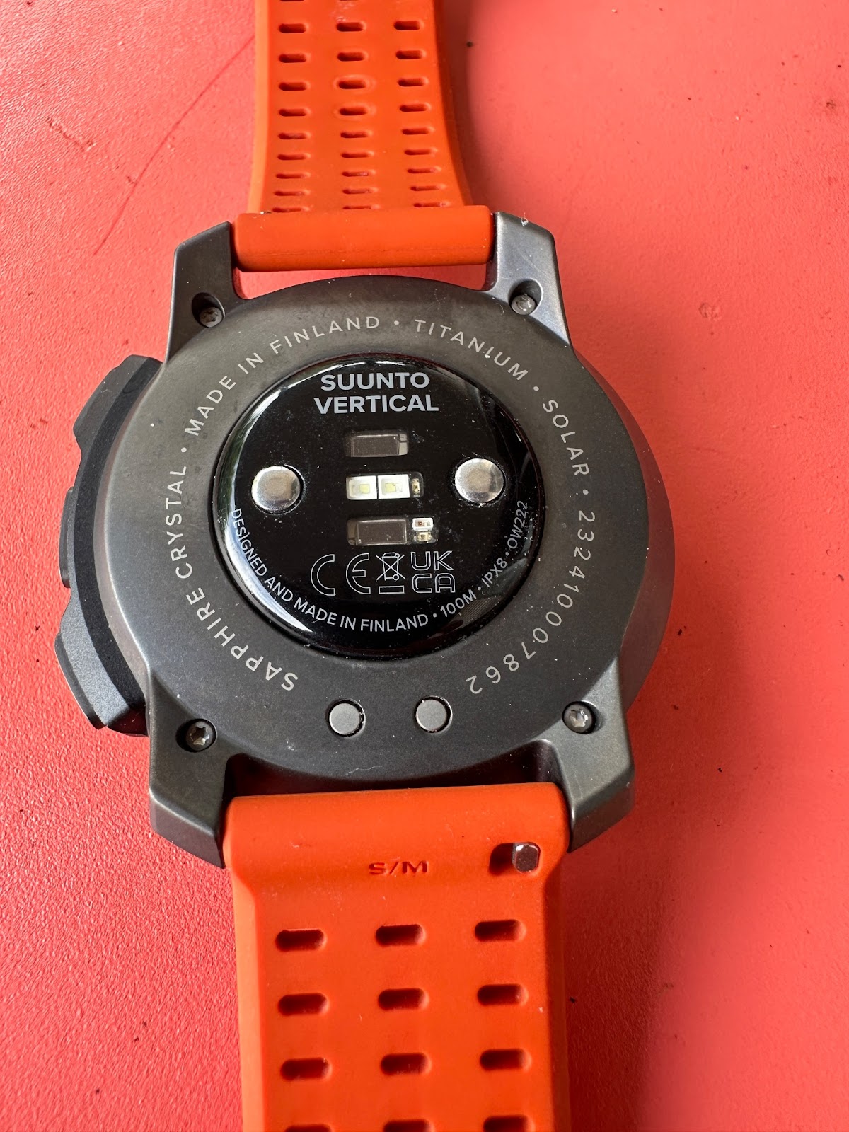
- Rugged Titanium and Sapphire build
- Comfortable and relatively thin and light at 73 grams (silicone strap)
- Lots of swiping: watch everyday screens could be simplified and reduced in number.
- Optical HR accuracy requires watch to be very tight on wrist (remains comfortable)
The Suunto Vertical is an all new watch from the storied Finnish brand. Its highlights are a spec 60 hour GPS battery life in Best Mode/Dual Frequency, a high resolution 280 x 280 transflective matrix touch screen, on watch outdoor maps, and a strong sustainability design as 100% of the product's 6.59 kg Co2 carbon footprint is compensated. It is 100% manufactured with renewable energy, in Finland. A true multisport watch, it has a durable titanium bezel, a sapphire crystal and solar charging. At 73g it is reasonably light given its silicone band.
Specs


All the Vertical’s official specs can be found HERE
Screen Legibility

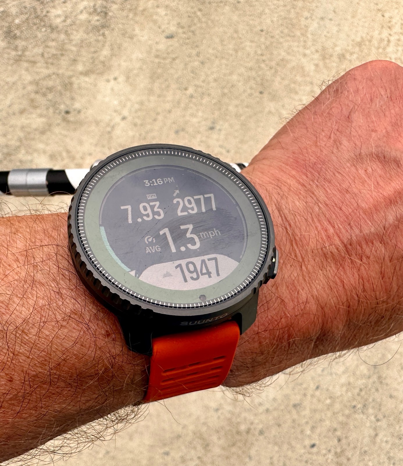
Always vital for me is screen legibility and visibility on the run and here the 280 x 280 resolution 1.4” display is outstanding. Data screens are crisp and highly legible in all light with the fonts sufficiently “fat” to stand out.
Further, compared to other watches, even those such as the Garmin Enduro 2 with the same display size and resolution, data screens and maps are more legible even if the maps are less detailed.
I will say that the sapphire display lens accumulates sweat and fingerprints and gets more “smudgy” than Gorilla Glass type lenses, as all such lenses tend in my experience,
The only displays that outdo the Vertical’s for me are AMOLED displays such as on the Apple Watch Ultra 2022 Super Sports Watch Comparison Review and Garmin Epix Gen 2 (RTR Review) although these much more battery hungry displays have significantly lower activity battery life with Apple Watch at 12-14 hours and Epix 2 at 32 hours whereas here we are at 54 hours in my testing in GPS Best Mode.
Interface
The watch interface and data presentation should be quite familiar to recent Suunto watch users. We have both a touch screen and three right side buttons.
During activity Start/Stop is top right, The middle button to cycle through screens is inset and easy to find with the lap marker the bottom button.
I like the broad flat shape of the buttons which make the watch notably easy to use on the run.
In everyday mode the top button takes you to your stored activity profiles to start one. Bottom button takes you down to Map, Compass, Logbook, Media Controls, Timer, Alarms, Do Not Disturb, Flashlight, Backlight, Watch Faces (limited), and Settings.
In everyday mode cycle through the 16 screens (shown below) via the middle button or swipe via the touch screen. To enter swipe/touch mode you need to press the center button once to unlock.
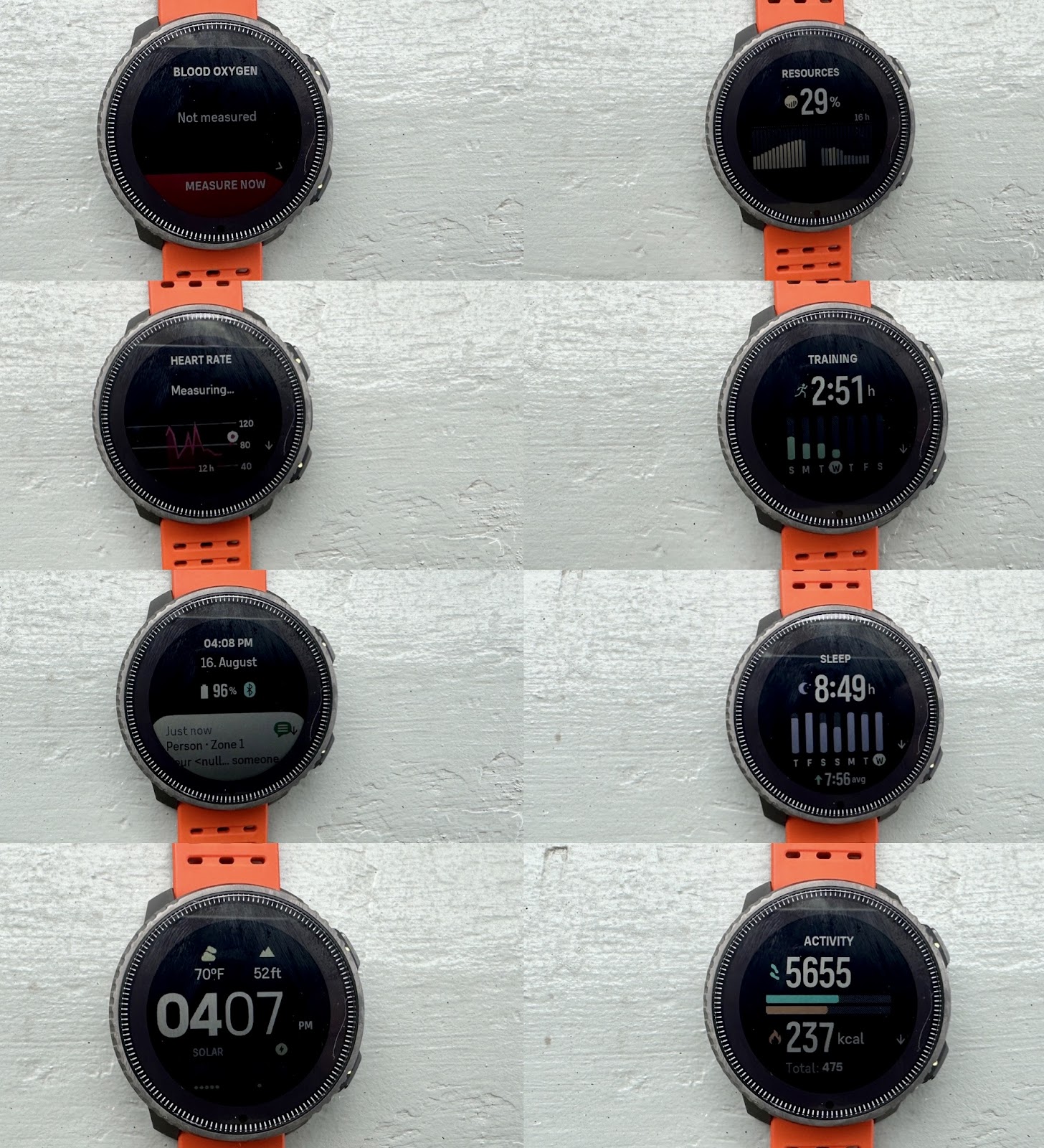
The first set shown above includes Data Watch Face, Notifications, Heart Rate, Blood Oxygen, Activity, Sleep, Training, Resources and Fitness Level.
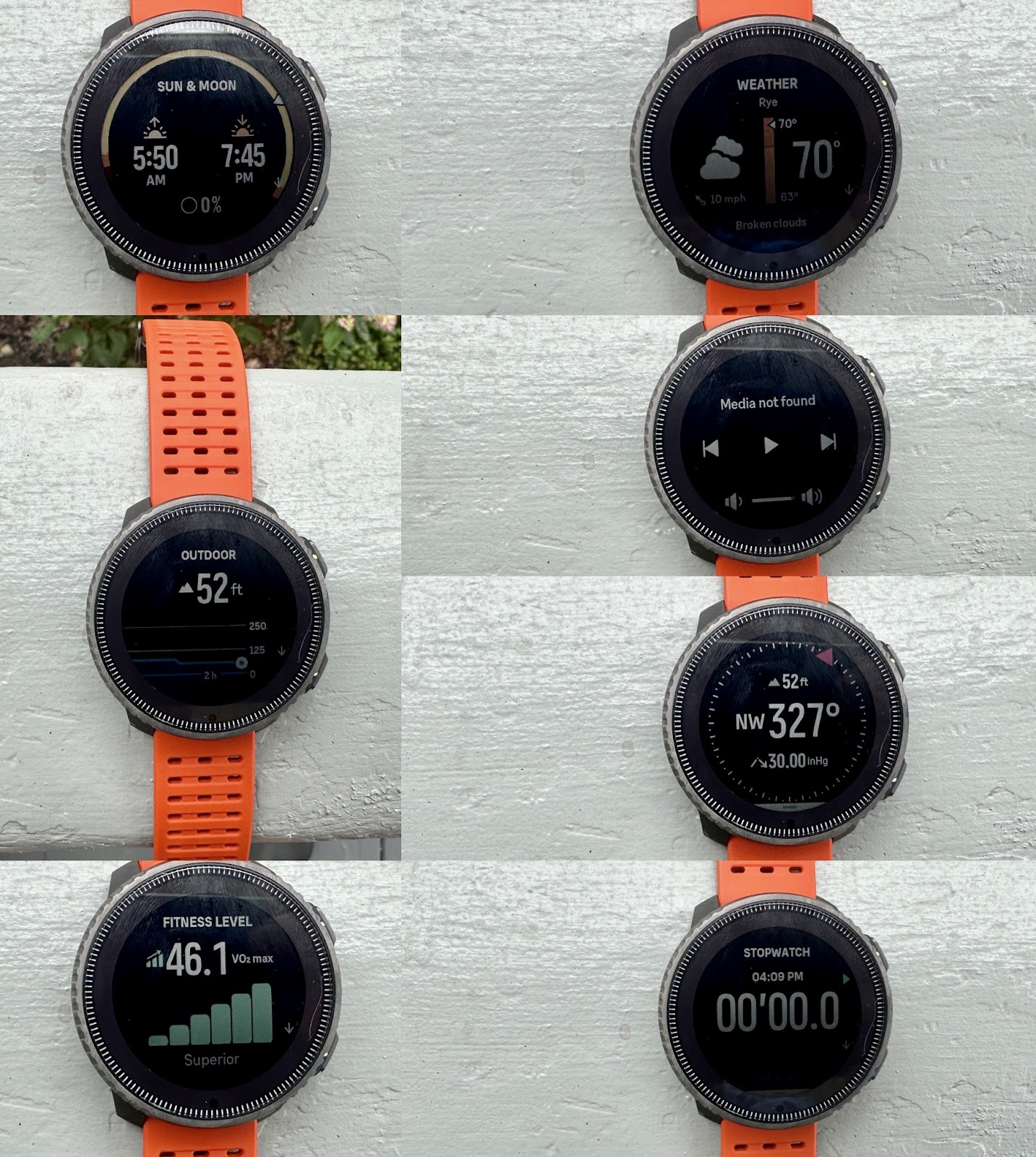
Continuing on, above we have Altimeter, Sunrise/Sunset, Stopwatch, Media Controls, Weather, and Solar Energy Charging graph (not shown but also on Watch Face). As far as I can tell you have to cycle through all screens (either direction fine) to exit to the main watch face.
See the video below for a live demonstration including deeper dives into each screen as well as a demonstration of activity.
I would prefer “snapshots” of the data for the various metrics on a single screen as Garmin does in Glances and as Coros also does with the ability to scroll down, see the basics and dig deeper.
Alternatively, they could be grouped by topic so for example (HR, Blood Oxygen, Resources, Fitness Level together with another grouping for Weather, Sunrise/Sunset, Altimeter, and Compass with the ability to dive deeper from these groupings on single screens. Here each screen is stand alone with several having deeper dives making it hard to navigate if your interest is more specific or you wish to just scroll by multiple top line metrics quickly
Data Fields

As is typical for modern sport GPS watches, we have dozens of data fields, although I do not yet see one for battery % or battery hours left. They are chosen and configured via the Suunto app. The list is shown in the short video below which also includes a tour of summary data, SunntoPlus apps and what we see viewing a specific run activity.
If you want to use Suunto Plus apps such as Climb, Ghost Runner, Strava training effect, Safe (my location) or Training Peaks you select these (turn on as many as you wish) from the Start activity screen before starting or during the activity when the watch is paused.
Once SuuntoPlus apps are turned on, they will appear for each activity in the Sport Mode. GPS settings, Media Controls, Auto Pause, Target, Intensity Zone, Backlight, connect to external HR strap and many others are available on or off for each Sport Mode.
You have to be on the watch face to sync with the app and to send your final workout data to the app.
GPS
As has been the case with all recent major brand watches with their new generations of sensors GPS accuracy is much improved over watches even 3 or so years old. The Vertical can tap into all five major satellite networks (GPS, GLONASS, GALILEO, QZSS, BEIDOU) via dual frequency. GPS satellite acquisition is fast with the Vertical consistently acquiring GPS ready to go within less than 6 seconds.
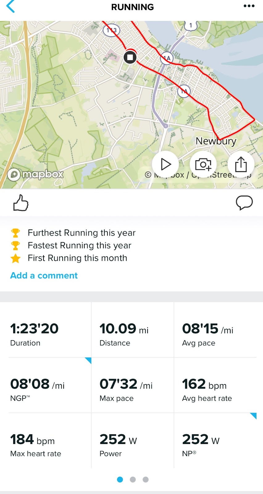
As shown above, with the Vertical on one wrist and Garmin Forerunner 265 on the other, distance during my recent 10 mile race was identical with average heart rate within one beat at 163 vs 164 bpm.
In a one on each arm test of Vertical and a Forerunner 265 I ran in each direction on the same trail under very heavy tree cover.

Comparative mapping: DC Analyzer.
One can clearly see the Vertical out performing the 265 with Vertical track (purple) in both directions closer together. While the 265 may not have as powerful an antenna as a smaller watch the Vertical was much closer to center of the trail
Heart Rate Accuracy
I do find that a relatively heavy 73g that the Suunto must be cinched very tight to avoid cadence lock type very high inaccurate readings the HR sensors confusing run cadence with heart rate)If it is not, you will see very high readings early in runs. During the race all was good but for one spike as shown below (red) but I have seen high readings with less than a snug fit, particularly and interestingly at slow paces.

Average cadence was very close with 176 strides/min for the Vertical and 178 for the Forerunner.
I do see the two disagreeing on average power by a substantial amount 252 W for Suunto and 338W for the Garmin but have no clue which is more “accurate”.
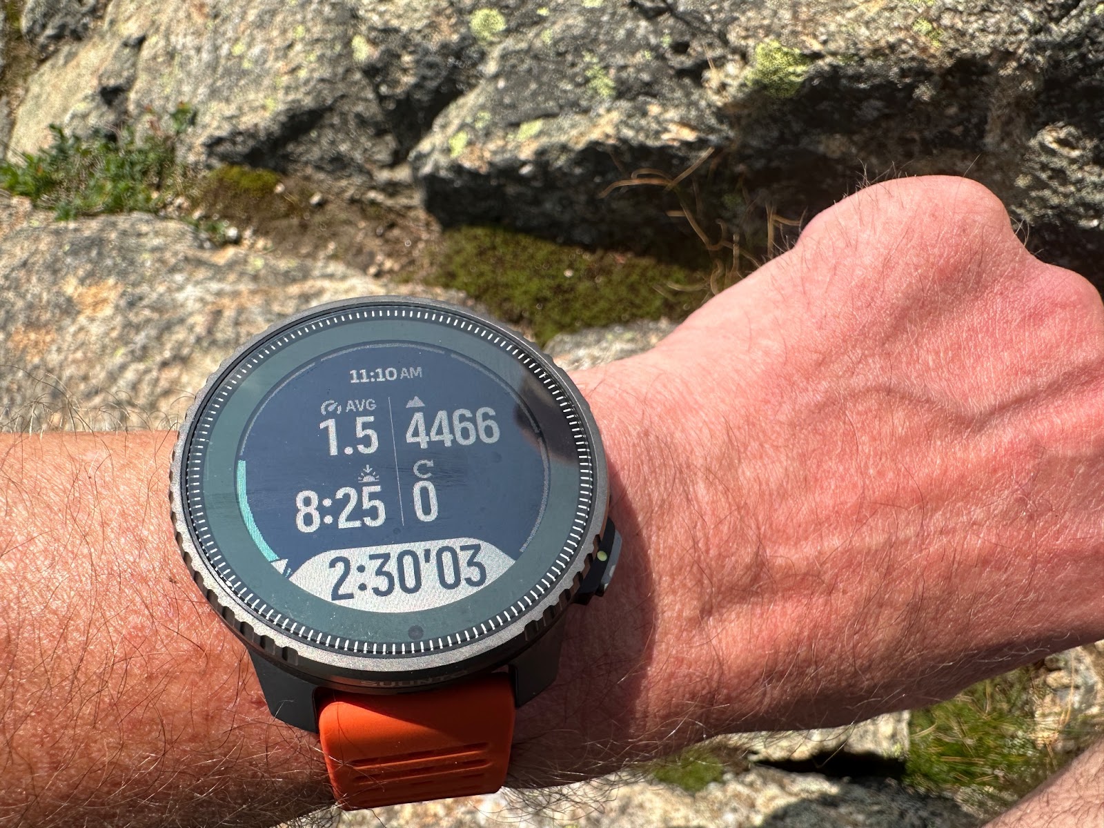
Battery Life
I did a 10 day battery test during which time I used 87% of the battery. I wore the watch for all activities with GPS in best mode, averaging 105 minutes per day of activity. In everyday mode, I had 24/7 heart rate off but with it on during sleep and with notifications from the phone active. Extrapolated to 100% of the battery with the same GPS activity I expect about 11.6 days of battery.
A second 8 day test with a more typical 70 minutes of GPS activity and 24/7 heart rate monitoring indicates 13 days of battery life. Quite remarkable!
I tested GPS battery usage during 2 hikes of 5 and 6 hours respectively. Notifications from the phone were on. Solar charging was likely low as we were under dense tree cover for a good part of both hikes. I estimate between 52 and 54 hours of battery life during GPS activities with maps enabled and used, touch disabled and screen timeout set to off. Most of the hiking was under dense tree cover. This translates to about 1.83 hours per 1% of battery life in GPS best mode
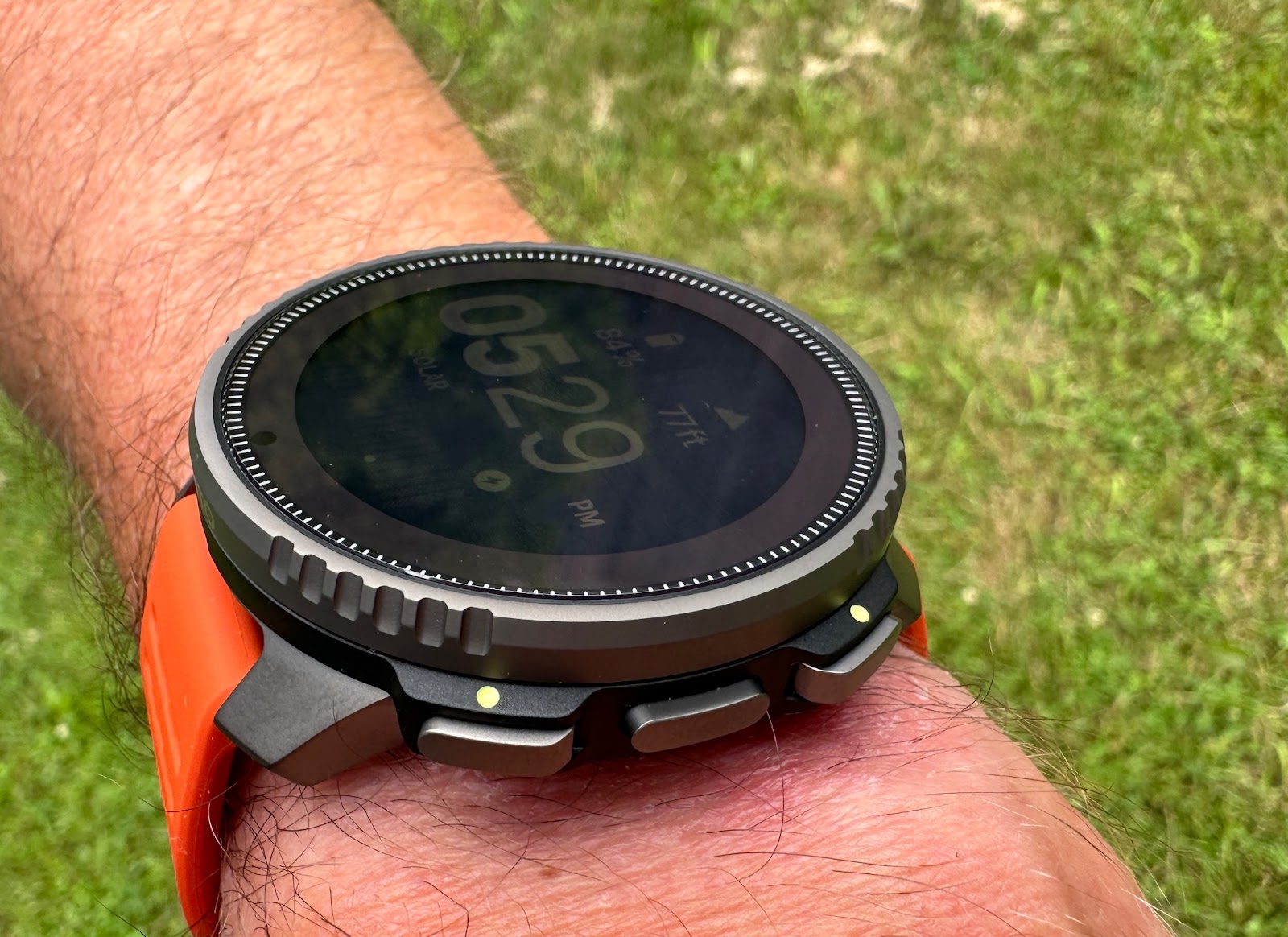
Solar Charging
3 hours in direct sun charged 2% so the equivalent of a bit less than 2 hours of additional GPS tracking time. While handy, I am not sure how much value solar charging adds and further the green solar ring takes away from the real estate for a yet larger display although a larger display likely would also consume more battery. Always tradeoffs in the balances a watch maker has to navigate
Charger
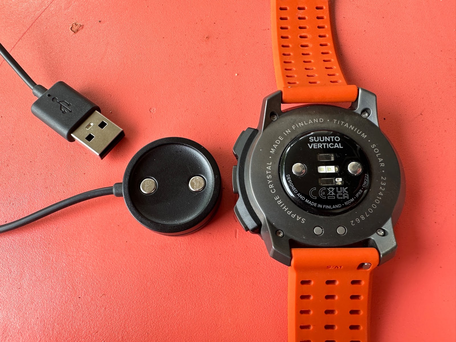
The charger is a magnetic disk with standard USB connection at the other end.

Holding watch by charger cord
The magnetic hold is good but I wish for a yet more solid grip to keep it from rotating as there is nothing more annoying than inadvertently knocking the watch and finding it has not charged hours later. That said, the battery life is so long here that charging is really just an occasional “thing”.
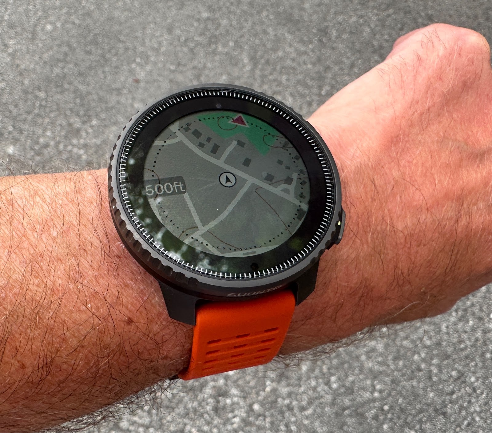
Navigation Maps and Routes
The Vertical includes maps in 2 main views:
Outdoor
With greater steepness of terrain the contour lines come into clear view. Here there is one brown contour line snaking through the bottom of the display.
High Contrast

Maps are loaded to the watch via free downloads via WiFi for areas of interest, in the US by states. In my case, I downloaded the entire state of New Hampshire where I live for offline use.
Unlike higher end Garmin (Epix and Enduro for example) the entire country/area is not “built in”. Download is via WiFi and I found it quite lengthy, do so overnight or plan on more than a few hours. Things are a bit complicated though. I found before I downloaded maps for my area I still had maps but at a resolution of 500 feet max from where I was located. When zooming out further the map did not show (all black screen). Strangely at the closer resolution I could see detail down to the individual house level. It appears the close in maps may be based on the last sync of the watch to the app? So make sure you download appropriate maps for your area. The max map zoom out is 0.5 miles.
It is important to note that while the app for routing has street and trail names as well as summits do not appear while viewing maps on the watch. I am assuming this is to reduce screen clutter and maybe storage needs but they would be nice to have.
If you have your phone and a signal your location and far more detail will show in the app view of maps.
I also find the weight of lines for trails which are shown but not on a route too faint and could be bolder for easier on the go viewing and in difficult light as shown below while the route taken so far and to go is almost too bold.
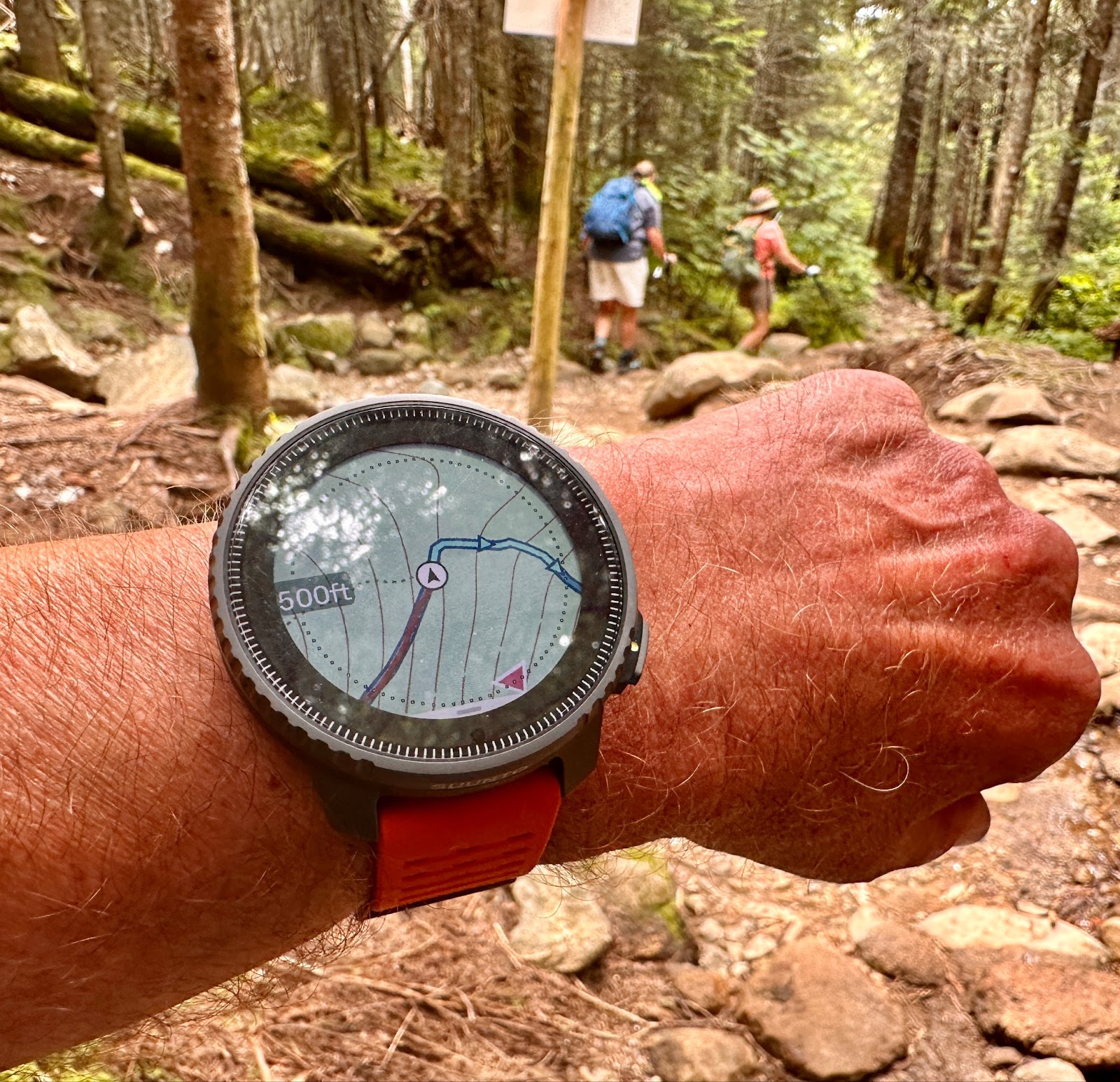
The trail ending at the signed junction is the dotted black line to the right of “500 ft”, the trail taken is red and the path to follow is blue. Trails names do not show on the watch but do momentarily for a loaded route when the turn by turn directions indicate a turn.
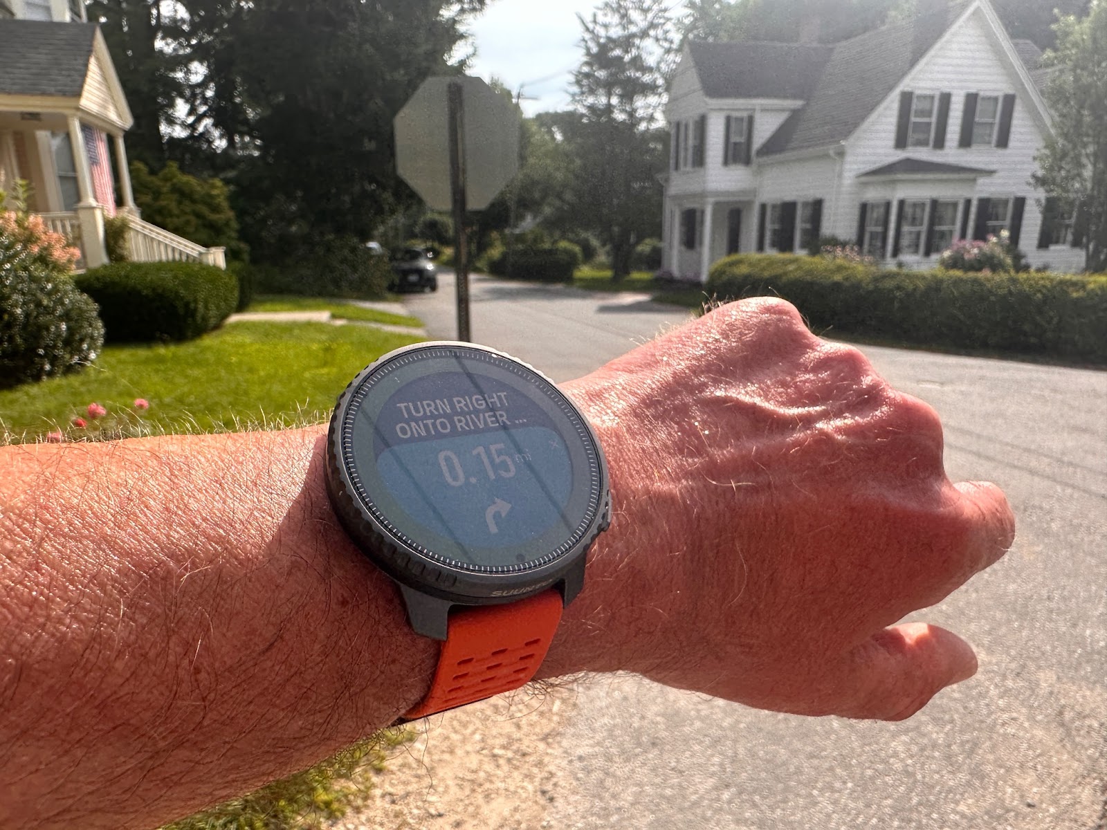
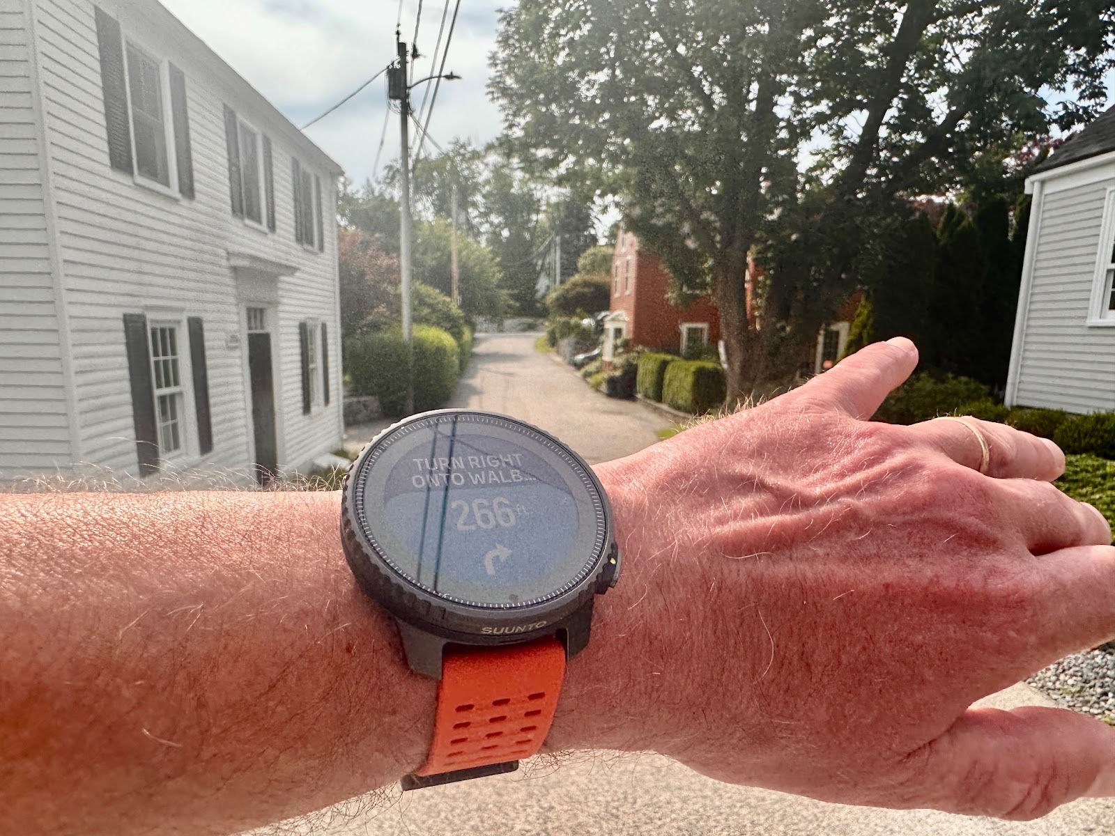
You want to glance for what is ahead, not what is passed. In the turn by turn directions the watch does show the name of the path (trail or road) to take before, with the actual junction turn direction and how far to the next junction indicated.
Unfortunately, so far, the whole name of the path to take is cut off as shown in the photos below as the fonts are too large as is the arrow. I think the arrow could be smaller and the full name included. Small adjustments for Suunto. The vibration buzz announcing the junction is also in my view too short and faint and easy to miss with the turn indicator a bit too brief before it disappears.
If a route is loaded the watch will notify you between 250 and 290 feet before the junction and then right at the junction the turn direction and distance to the next junction as shown below.
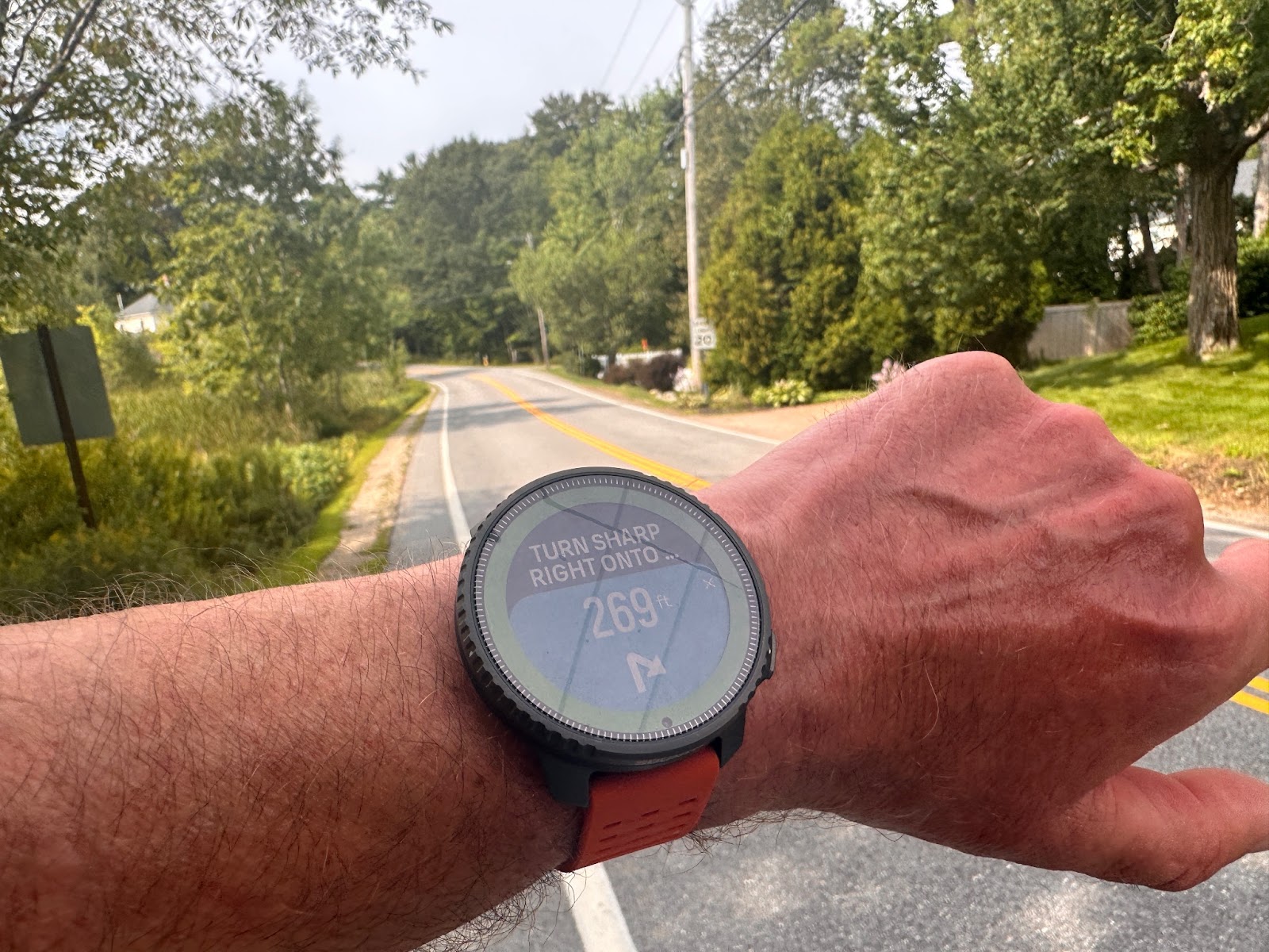
The Right turn is at the 2nd pole on the right. Note road name is not visible. A simple “Right Onto” with the full name of the road to be taken with the arrow indicating “Sharp” visually and distance digits smaller would be plenty to get the message across
At the junction our next turn including a very partial road or trail name and distance to that turn is announced
Below we have a trail example. After Mount it should say Osceola Trail in the top picture. At the junction (in the light area at top of bottom picture) it tells us we have 5.01 miles to our next junction, Tripoli Road and the end of our hike.

I have noticed on more than one occasion that the direction to take seems inverted from what it “should be" based on the loaded route.
The above is supposed to be a Left turn but…ends up a brief Right. Why?
Well, without noticing it in setting up the route, I must have clicked a bit off my main route and at another road with the mapping picking up a very, very short out and back that I did not notice.

Above the short right turn and leg indicated in the route set up in the app and shown in the Turn by Turn Directions in the photo above
Not sure how Suunto can fix this, maybe using a bit more AI to determine that my click was off by a bit and my intention was as in the next segment clicked off so ignore the dog leg? Similar short off “trails” have happened several times for both road and trail routes, including more than once in setting up this particular route. The quick fix is of course to zoom in closer as you select a route’s path.
One feature that I really like in higher end Garmin, but not present, as of yet in the Vertical is something like their Next Fork. Even if a route is not loaded and Epix 1 and now also Fenix will indicate the distance to the next junction or “Fork” and name of the path/road at the next junction. With such capabilities one can pass on loading routes if the purpose is just to navigate.
To zoom in to a map do a single click on the top right button to zoom in with a longer hold to zoom out. If you want to move out of maps, or in any data screen navigate to the next in your line up simply press the center button. Literally I can never remember how to get out of maps in Garmin. Here it is very simple.
Altimeter
I tested the altimeter vs the Garmin Enduro 2 at two New Hampshire 4000 foot summits as well as solo at another where the elevations are precisely known. I did not pre calibrate either watch for the hikes.
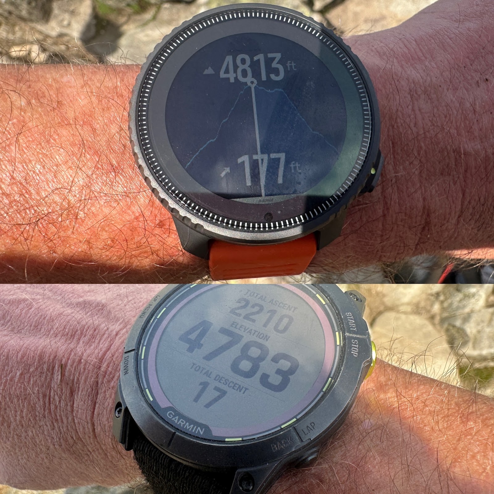
On the summit of Mount Moosilauke with an official altitude the Vertical had me at 4813 feet with the Enduro at 4873 feet
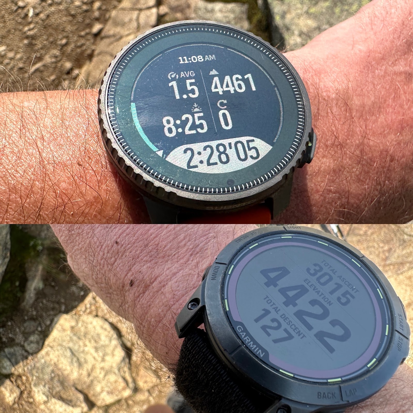
On the summit of Mount Liberty with an official altitude 4459 feet the Vertical had me at 4461 feet with the Enduro at 4422 feet.
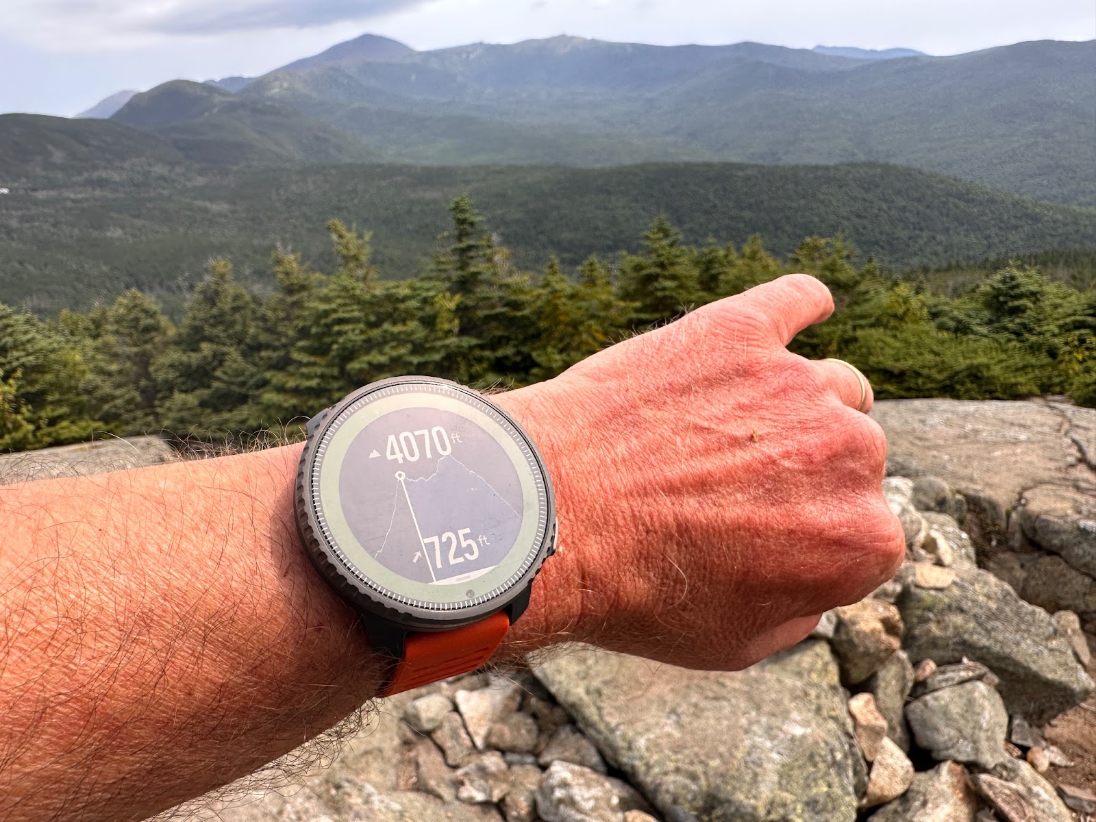
On the summit of Mount Jackson with an official altitude of 4070 feet the Vertical had me at 4052 feet.
Flashlight
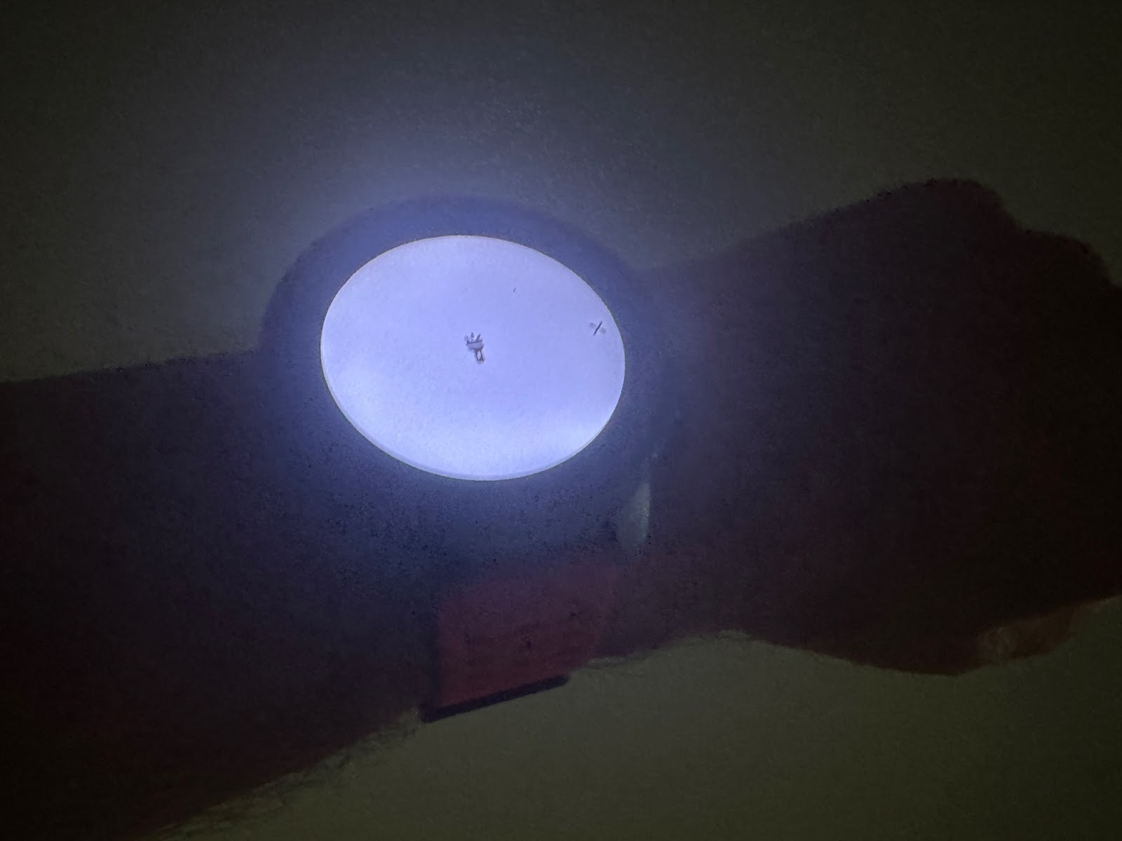
The Vertical includes a “flashlight”. Accessed from the main menu or from an activity after an auto or manual pause the flashlight essentially illuminates the entire screen in bright white. It is not a separate light module on the front edge of the watch as in the Garmin Enduro 2 and Epix Pro which is a serviceable flashlight. It currently only has one mode so no strobe or red light for night vision preservation.
It is bright enough for finding things in camp, navigating the house in the dark, maybe some easy night walking but not a lot more than that and while it is on the rest of what you might see is of course not visible.
Sleep
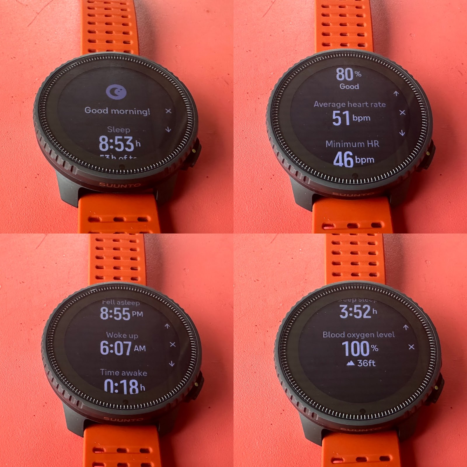
Suunto’s on watch Sleep data is complete and similar to Garmin’s but not nearly as sophisticated as Polar’s dual data scoring (ANS and actual sleep) with scores for each and a combined score indicating recovery at wake up. We get a percentage “80%” and a word “Good”. There is no visible heart rate variability taken into consideration and I wish there was as it has been shown to be a clear and valuable signal of recovery or not.
There is Blood Oxygen level as part of Sleep which here at sea level is almost always 100% at wake up. Of course at altitude, this metric becomes more important. The Blood Oxygen level can also be taken at any time from one of the main screens.


Graphs can be adjusted for different metrics at the top left and right drop downs as shown above.
Resources (readiness for efforts in Suunto speak)
Suunto’s Resources metric uses a combination of sleep, stress and activity to calculate how full your tank is for effort. It uses your 24/7 heart rate readings (must be turned on) as well as your resting and maximum heart rates so set those carefully. I have seen online advice to set resting HR 10bpm higher than actual as it seems I never have enough Resources. Expressed as a percentage, it is useful but a bit too opaque for my taste. I would like to better understand its components and their weightings.
Watch Comfort

For a relatively “big” watch the Vertical is comfortable at all times even during sleep, for me the key test of comfort. The buttons are high enough placed on the case and are all on one side. Key to comfort is also the 13.8mm case thickness, considerably thinner than say a Fenix 7 at 14.5 mm and much thinner than a Coros Vertix 2 at 15.7mm or an Enduro 2 at 15.6mm.
App Data
See our previously mentioned video HERE for a tour of the app.

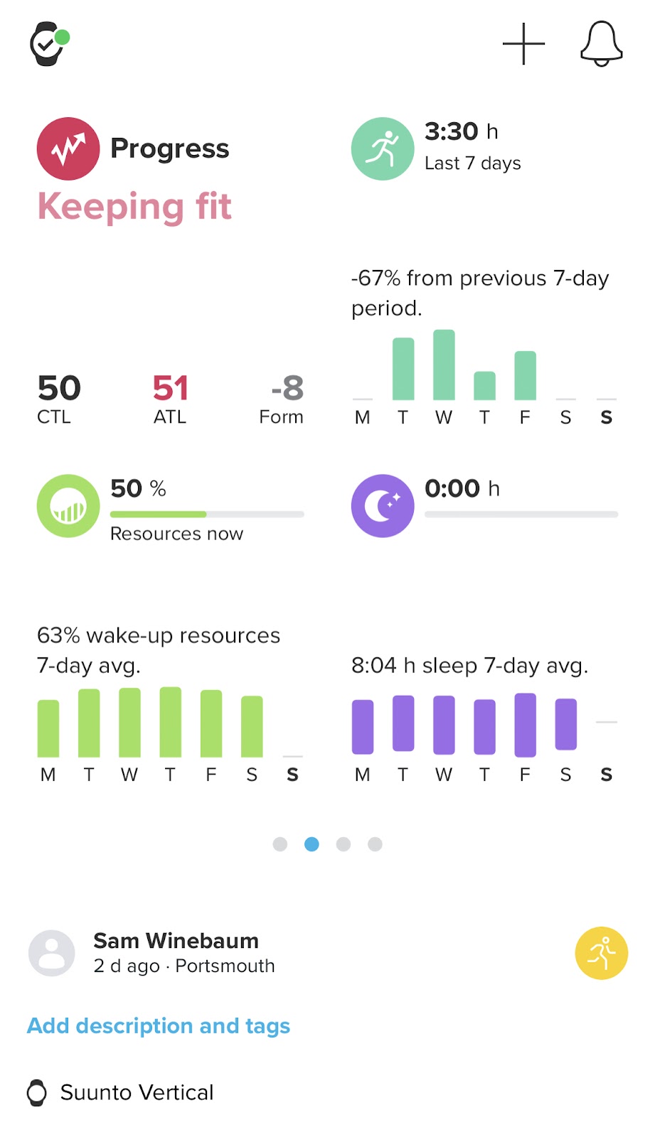

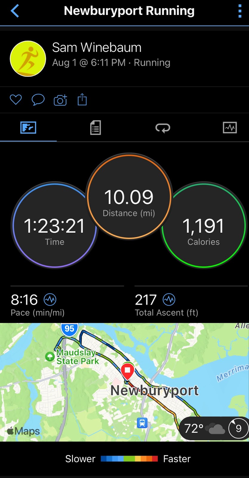
Illustration of Data from a Run Activity in the Suunto App.
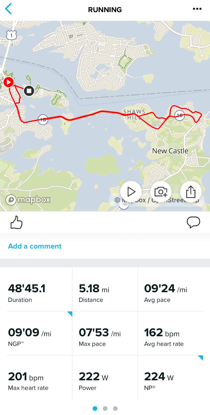


(Note high wrist HR readings. I did not have the strap nearly as tight enough and it was raining heavily)

Conclusions
The Vertical is a rugged, state of the art sports watch with notable strengths in GPS accuracy, Best Mode all frequencies battery life, screen legibility/resolution which exceeds its direct competition at Garmin in the Fenix series and is leveraged into very easy to read if simple topo and road maps and clearly seen all light conditions data screens.
It also benefits from being light in weight at 73g even with a “heavy” silicone strap and a thinner profile so is more comfortably worn day in day out and when sleeping. I wish it was also delivered with a nylon strap as others are now doing for watches in its price class to reduce weight further.
Optical heart rate is solid but depends on making sure the silicone band is very tight (although never uncomfortable as it has some stretch). If it is not, high readings were noted.
The new topo and road maps as well as turn by turn directions are useful but could use some reduction of font sizes and line weights to display more information. I would also like to see judicious labeling of roads, trails and summits on the watch.
The non activity daily use watch data screens could benefit from summary screens with more than one top line metric per screen with detailed access below to reduce the amount of scrolling. As with the data screens in activities, screens are are highly legible in all light conditions but overly large in fonts for the uses of such screens when one is not in an activity.
The Vertical lags in a few areas as outlined above, likely software and interface tuning related. It is a solid value for sure on the hardware and durability side given its strengths and its titanium bezel and sapphire crystal. I hope and expect as the new platform evolves Suunto will continue to evolve and improve the Vertical’s “softer” on the watch side of the equation.
Comparisons
Fenix 7 ($800-47mm) and Fenix 7 Pro Sapphire Solar Edition ($900 47mm) RTR Review of 51mm version of Pro
The $839 Vertical has a nearly identical weight, 2mm more case diameter diameter and at 13.6mm thick is 1.1mm thinner which is actually noticed when sleeping. Battery life in GPS Best Mode is nearly the same at 57 hours for Fenix Pro (GPS only) by spec and 60 hours by spec for Vertical (all systems tracking Best Mode/dual frequency) but as said in the article based on default settings I am seeing closer to 54 hours for Vertical. I did not test either Fenix to verify its battery spec.
The Vertical has a larger 1.4” display (1.3” for Fenix) with a higher 280 x 280 resolution (260 x 260 for both Fenix).
Both Fenix include a clearly more functional flashlight and the highly useful Next Fork navigation.
Garmin Enduro 2 ($1100) RTR Review
TheVertical display size and resolution is identical to the $1100 Enduro 2 I tested side by side with the Vertical. The Vertical display was clearly crisper and had superior legibility. Not sure how but it was noticeable.
The much thicker 15.6 (mm) Enduro 2 is not as comfortable to wear but weighs 3g less than the Vertical with its nylon strap (silicone also included which adds to its weight). Yes, the Enduro has longer GPS battery life at 68 hours without going solar but I don’t think many need to pay a premium for that much more battery life, Vertical has more than enough for most uses.
Coros Vertix 2
The $700 Vertix 2 matches the Vertical in resolution and display size. It is considerably thicker at 15.7mm and less comfortable to wear everyday and for sleep as it is also 16g heavier with silicone band. It has a larger 50.3mm diameter and also has aSapphire lens and Titanium bezel. The Vertical has better GPS dual frequency battery life for all satellite networks at 54 hours (my testing) spec 60 hours while the Vertix 2 has 50 hours at dual frequency and up to 90 hours 5 networks without dual frequency.
The Suunto Vertical Titanium Solar as well as a steel version ($629) is available at our partners below
Samples were provided at no charge for review purposes. RoadTrail Run has affiliate partnerships and may earn commission on products purchased via shopping links in this article. These partnerships do not influence our editorial content. The opinions herein are entirely the authors'.
EUROPE Men's & Women's SHOP HERE
Europe only: use RTR code RTR5ALL for 5% off all products, even sale products
- 10% Savings Every Day* 5% Back in Rewards Cash
- Test Run Shoes 90 Days Worry Free
- Crazy Fast, FREE Shipping
- NONSTOP PERKS

AMAZON
No comments:
Post a Comment